Tampilkan postingan dengan label nature. Tampilkan semua postingan

Kamis, 28 Januari 2010

10 Highest Mountains Of The World

10. Annapurna Mountain – Nepal


It is the tenth highest summits on the earth, which is found in Nepal with an elevation of 26,545 feet and 8,091 meters.

9. Nanga Parbat – Pakistan


Nanga Parbat is the ninth highest mountain of the earth that is located in Pakistan at the heights of 26,758 feet and 8,125. It is one the dangerous and deadliest eight-thousanders for the climbers and to climb it, is a predictable risk.

8. Manaslu Mountain – Nepal


Manaslu is the eighth highest mountain of the world, and it is located in Mansiri Hima with within Nepalese Himalayas with an elevation of 8,163m (26,758).

7. Dhaulagiri Mountain – Nepal


Dhaulagiri lies on number seven in the list of the top ten highest mountains of the world, and it is located in north central Nepal and now has become the pivot point of the tourists and climbers. Its height is 26,794 feet, or 8,167 meters. It is also called White Mountains for being one of the eight thousanders.

6. Cho Oyu Mountain – Nepal/Tibet


Cho Oyu is the sixth highest mountain of the world, and it is located in the Himalayas on the border that lies between china and Nepal, this mountain is also known as “Turquoise Goddess” in Tibetan. The height is this mountain is 26,906 in feet or 8,201 in meters.

5. Makalu Mountain – Nepal/Tibet


Makalu Mountain is the fifth highest mountain on the earth, with an elevation of 27,765feet, 8,463meters, it has different official names in different language. It is situated on the border that connects Nepal and China.

4. Lhotse Mountain – Nepal


Lhotse has two different names, Lhotse an official one, in Nepal and second is Lhozê in Chinese language and it is the fourth highest mountain of the world, amazingly it is linked to everest with the south Col. It is located on the border that links up between Tibet (China) and Khumbu (Nepal). Its height is 8,511m (27,940 feet).

3. Kangchenjunga Mountain – Nepal/India


Kangchenjunga is the third highest mountain of the world, which height is 8,586 metres (28,169 ft). If we try to find out the meanings of this complex name Kangchenjunga, then it is wonder that meaning is quite semblance to a story name, and the translated meaning is “The Five Treasures of Snows”, this name is awarded to this mountain because it is blessed with five treasures of God that are gold, silver, gems, grains and holy books.

2. K2 (Mount Godwin Austen) – Pakistan


K2 is positioned on number 2 in the line up of the world’s highest mountains and it is second after Mount Everest, its measured height is 8,611m (28,251 feet), it is also situated on the border like Mount Everest and connects countries with each other for example, in links up Taxkorgan Tajik Autonomous County of Xinjiang, China and Gilgit, in Gilgit-Baltistan of Pakistan. As it is situated on the peak that’s why it is a risk to climb this mountain and many of people died trying so. The famous Climbers like to climb onto it, but in winter nobody dares think of climbing.

1. Mount Everest – Nepal/Tibet

Senin, 18 Januari 2010

Top 10 Abandoned Islands On The World

(1)Falkland Islands

The Falkland Islands are an archipelago in the South Atlantic Ocean, located approximately 300 mi from the coast of mainland Argentina, 700 mi from mainland Antarctica, and 3,800 mi from Africa. There are two main islands, East Falkland and West Falkland, as well as 776 smaller islands. The islands are a self-governing Overseas Territory of the United Kingdom and Stanley, on East Falkland, is the capital.
Ever since the re-establishment of British rule in 1833 Argentina has claimed sovereignty. In pursuit of this claim, which is rejected by the islanders, Argentina invaded the Falkland Islands in 1982. This precipitated the two-month-long undeclared Falklands War between Argentina and the United Kingdom and resulted in the defeat and withdrawal of the Argentine forces.
Since the war, there has been strong economic growth in both fisheries and tourism.


(2)Xisha Island

Xisha Island, 329 kilometers from the nearest mainland province of Hainan, located in the waters of the South China Sea. It is known that specific types of birds that live only on this island and rare tropical plants.


(3) Tristan da Cunha

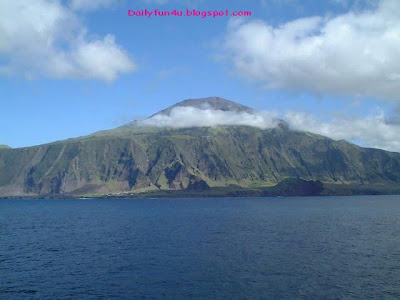
Tristan da Cunha is a remote volcanic group of islands in the south Atlantic Ocean, and also the name of the main island of that group. It is the most remote inhabited archipelago in the world, lying 2,816 kilometres from the nearest land, South Africa, and 3,360 kilometres from South America. It is part of the British overseas territory of Saint Helena, Ascension and Tristan da Cunha which also includes St Helena 2,430 kilometres to its north, and equatorial Ascension Island even farther removed, grouping the British South Atlantic islands into one far-flung centrally administered aggregate. Tristan da Cunha is said to be the “most remote inhabited location on Earth. It has a population of 275.
The territory consists of the main island of Tristan da Cunha itself, which measures about 7 miles across and has an area of 98 square kilometres, along with the uninhabited Nightingale Islands and the wildlife reserves of Inaccessible Island and Gough Island.


(4)Saint Helena

Saint Helena is an island of volcanic origin in the South Atlantic Ocean. It is part of the British overseas territory of Saint Helena, Ascension and Tristan da Cunha which also includes Ascension Island and the islands of Tristan da Cunha. Saint Helena measures about 16 by 8 kilometres and has a population of 4,255.
The island has a history of over 500 years since it was first discovered as an uninhabited island by the Portuguese in 1502. Britain’s second oldest remaining colony, Saint Helena is one of the most isolated islands in the world and was for several centuries of vital strategic importance to ships sailing to Europe from Asia and South Africa. For several centuries, the British used the island as a place of exile, most notably for Napoleon Bonaparte, Dinuzulu kaCetshwayo and over 5,000 Boer prisoners.


(5)Piticairn

Islands Piticairn four volcanic islands in the vast expanse of the Pacific, called the “paradise for the shipwrecked.” Food and other necessities to the island the ships that delivered each day prevaljuju time from 2172 km to get to this island. officially named the Pitcairn, Henderson, Ducie and Oeno Islands, are a group of four volcanic islands in the southern Pacific Ocean. The islands are a British overseas territory, the last remaining in the Pacific. The four islands – named Pitcairn, Henderson, Ducie, and Oeno – are spread over several hundred miles of ocean and have a total area of about 18 square miles. Only Pitcairn, the second largest and measuring about 2 miles across, is inhabited.
The islands are best known as home of the descendants of the Bounty mutineers and the Tahitians who accompanied them, an event retold in numerous books and films. This story is still apparent in the surnames of many of the islanders. With only 50 inhabitants, Pitcairn is also notable for being the least populated jurisdiction in the world. The United Nations Committee on Decolonisation includes the Pitcairn Islands on the United Nations list of Non-Self-Governing Territories. The Pitcairn Islands


(6)Kiribati

Kiribatiis an island nation located in the central tropical Pacific Ocean. It is composed of 32 atolls and one raised coral island, dispersed over 3,500,000 square kilometres, straddling the equator, and bordering the International Date Line to the east. The name Kiribati is the local pronunciation of “Gilberts”, derived from the main island chain, the Gilbert Islands. Kiribati became independent from the United Kingdom in 1979. It is a member of the Commonwealth of Nations, the IMF and the World Bank, and became a full member of the United Nations in 1999.Kiribati, an island located on the eastern land border of the planet, away from civilization is 2665 km. Woe is available to people, Kiribati and the largest protected marine reserve with beautiful beaches. On the remote island there is potable water, food and accommodation for tourists. Kiribatija is easiest to reach by air from Honolulu.


(7)Galapagos

The Galapagos Islands are an archipelago of volcanic islands distributed around the equator in the Pacific Ocean, 972 km west of continental Ecuador. It is a UNESCO World Heritage site: wildlife is its most notable feature.
The Galapagos islands and its surrounding waters are part of a province, a national park, and a biological marine reserve. The principal language on the islands is Spanish. The islands have a population of around 40,000, which is a 40-fold expansion in 50 years.
The islands are geologically young and famed for their vast number of endemic species, which were studied by Charles Darwin during the voyage of the Beagle. His observations and collections contributed to the inception of Darwin’s theory of evolution by natural selection.
The first crude navigation chart of the islands was done by the buccaneer Ambrose Cowley in 1684. He named the individual islands after some of his fellow pirates or after the English noblemen who helped the privateer’s cause. More recently, the Ecuadorian government gave most of the islands Spanish names. While the Spanish names are official, many users continue to use the older English names, particularly as those were the names used when Charles Darwin visited.


(8)Easter Island

Easter Island is a Polynesian island in the southeastern Pacific Ocean, at the southeastern most point of the Polynesian triangle. A special territory of Chile annexed in 1888, Easter Island is widely famous for its 887 extant monumental statues, called moai (pronounced /?mo?.??/), created by the early Rapanui people. It is a World Heritage Site with much of the island protected within the Rapa Nui National Park. Historically the island has experienced a collapse of its ecosystem, with extinction of many of its prehistoric species; these events were associated with over-exploitation of the island’s resources. The underlying island geology is one of extinct volcanoes. Easter Island, 2076 km away from the mainland, known by a large stone statues of human heads. Despite the great distance of Chilea, there are regular flights to line Easter Island. On the island there are a number of hotels and various tourist activities such as horseback riding and hiking.


(9)Cocos Islands

Cocos Island is a small island located about one mile off of the southern tip of Guam. Cocos Island Guam is sometimes confused with the Australian territorial Cocos Keeling Island, but they are in fact many miles apart. Cocos Island Guam is a popular place for visitors to escape for a day to shop, fish, snorkel and hang out on the beach. Cocos Island Guam is one of the many great reasons to take a vacation to Guam and provides beautiful views for any trip.
Cocos Island history reflects the history of the Chamorro people as well as Spanish traders. Although Cocos Island is today a major tourism attraction, it was once the site of a major ship wreck. In June of 1690 the Neustra Senora del Pilar de Zaragosa y Santiago hit the southern reef at Cocos Island.


(10)Attu

Attu is the westernmost and largest island in the Near Islands group of the Aleutian Islands of Alaska, making it the westernmost point of land relative to Alaska and the United States. It was the site of the only World War II land battle on United States soil, and its battlefield area is a U.S. National Historic Landmark.
Attu Station, the only inhabited area on the island, is actually located at 52°51′ north latitude, 173°11′ east longitude, making it by one definition one of the westernmost points of Alaska.

Minggu, 27 Desember 2009

The North Pole - Beautiful Nature Scene


The North Pole, once an almost mythical place visited only by the heartiest of explorers (and Santa Claus) is now a tourist destination. Though certainly not for everyone, those arctic lovers who are inclined can visit the North Pole by ship, helicopter, or submarine. The textbook definition of the North Pole is the point in the middle of the Arctic Ocean where the Earth’s axis of rotation meets the Earth’s surface. The North Pole is, of course, incredibly cold, though it is significantly warmer than the South Pole. Winter temperatures range from −43 °C (−45 °F) to −26 °C (−15 °F), and Summer temperatures average around the freezing point (0 °C, 32 °F). Tours to the North Pole can be found on a variety of specialty tour company websites.


Sabtu, 26 Desember 2009

Cappadocia Valley And Its Hidden Geological Beauty


Uçhisar

Cappadocia has dozens of underground cities, but the most elaborate ones are at Kaymakli and Derinkuyu. One of the most fascinating areas is Goreme, which accommodates an open-air museum that stands visually striking with its ‘fairy chimney’ volcanic cones. Surprisingly over 30 of the best-preserved churches of Cappadocia can be seen here. Avanos is another pretty town on the Kizilirmak, where inhabitants make their living from the malleable river clay for years, shaping everything from pots and roofing tiles to statues and more.


The huge and sprawling Selime Rock Monastery was carved out the rock by Christian monks in the 13th century. A steep climb is the only way to access it.

Kaymakli and Derinkuyu are known as Capadocia’s deepest and the most elaborate underground cities. Kaymakli was cut out of volcanic soft stone (tufa) as deep as 300 feet during the period covering sixth to the tenth centuries. The underground city of Derinkuyu is estimated to have twenty floors, out of which only eight can be visited today with an estimated capacity to bear 20,000 people.


Kaymaklı underground city


Map of the underground city of Kaymakli, Cappadocia, Turkey.

Soganli valley, Uchisar, Zelve, Urgup, witnesses some splendid scenery and age-old rock carved churches and chapels that are unique geographical, historical and cultural features. The pigeon valley between Goreme and Uchisar offers spectacular views of the natural cliffs and some fabricated caves, passing through few tunnels, carved within the rock. Nearly 35 multi-level complexes including the networks at Ozkonak, Derinkuyu and Kaymakli have not yet been fully explored.


Kaymakli underground city

These subterranean towns with carved out rock caves, pointed termite mounted looking structures has a supernatural feeling and it is almost magnificent in all directions. These cities were abandoned in late 14th
century.


Cappadocia Valley And Its Hidden Geological Beauty


Cappadocia in Turkey is an underground fantasyland of fairy chimneys and churches. The astounding geological beauty of Cappadocia is a wonder-destination of Central Anatolia. It is an extensive island district, where nature and history mix-match most beautifully. This fantasyland has so much to offer ranging from ‘fairy chimneys’ and churches cut out of soft rock formations to some amazingly intricate systems of tunnels and underground cities. It is an exotic diversity found in the crucible of culture where East meets West!


Village in Cappadocia

Cappadocia boasts of several underground hidden cities and intricate tunnels that were mostly used by early Christians as hiding places. The inhabitants could hide thousands of people and animals within these complexes, which had wells, chimneys, stables and even tombs.


Goreme – Celestial Canopy

The region was a Roman province and the refuge of persecuted Christians during the early days of the Roman Empire. For most of the Byzantine era, it remained relatively undeterred by the conflicts in the area, first with the Sassanid Empire and later against the Islamic expansion led by Arabs. Though the early Christians are credited with the building of this mysterious supercity but some historians believe that few parts date back to the end of the Ice Age – 9500 BC.


Fairy Chimney Hotel in Göreme


Cappadocia – Goreme Village by Traces in the Sand. The amazing and bizarre village of Goreme, literally cut from the strange rock formations of Cappadocia.

Nestled in the center of Anatolian peninsula, Cappadocia has become one of the most notable tourist destinations in Turkey. The uniqueness of the region was formed by the eruption of Mt. Erciyes and Mt. Hassan, some 60 million years ago that spread a thick layer of ash over the area. With time, this hardened into a soft porous stone known as tufa. Coincidentally, the erosion by rain and wind created valleys in the soft rock that left behind higher sections of interesting formations known as ‘fairy chimneys’.


Pigeon Valley


Central Turkey. Pigeon valley


The stunnig village of Uchishar at sunset


The Past and the Present – Pigeon Valley


Selime Monastery Jutting Rock


Senin, 14 Desember 2009

World's Oldest Living Tree-9,550 Year old


The world's oldest recorded tree is a 9,550 year old spruce in the Dalarna province of Sweden. The spruce tree has shown to be a tenacious survivor that has endured by growing between erect trees and smaller bushes in pace with the dramatic climate changes over time.

For many years the spruce tree has been regarded as a relative newcomer in the Swedish mountain region. "Our results have shown the complete opposite, that the spruce is one of the oldest known trees in the mountain range," says Leif Kullman, Professor of Physical Geography at Umeå University.A fascinating discovery was made under the crown of a spruce in Fulu Mountain in Dalarna. Scientists found four "generations" of spruce remains in the form of cones and wood produced from the highest grounds.The discovery showed trees of 375, 5,660, 9,000 and 9,550 years old and everything displayed clear signs that they have the same genetic makeup as the trees above them. Since spruce trees can multiply with root penetrating braches, they can produce exact copies, or clones.


Minggu, 13 Desember 2009

9 Gigantic Hearts Created By Mother Nature | Nature Or Love?

1.Heart Reef, Great Barrier Reef of the Whitsundays

Heart Reef is a naturally formed, heart-shaped collection of coral in Australia.


2.Galesnjak, Croatia

This beautifully shaped island can be found just south of Zadar in Croatia. Called Galesnjak, this little gem measures just 1/2 kilometre at its widest point and must be reached by boat.


3.Heart-Shaped Forest, Cantabria, Spain

This beautifully shaped forest can be found in Cantabria, Northern Spain. However, the forest will only take on the heart shape seen in the above photograph when viewed from this angle.


4.Heart-Shaped Island, Gutierrez Lake, Patagonia

A beautiful heart-shaped, tree covered island can be found in Patagonia, Argentina, and is best viewed from the East side of Gutierrez Lake.


5.Heart-Shaped Lake, Ohio

A perfectly heart-shaped lake can be found near Columbia Hills Corners in Ohio.


6.Heart-Shaped Lake, Chembra, India

Itself a major tourist attraction, the lake near the top of Chembra Peak in India is said to have never dried up. Apparently over 150 people pass the lake every day during the 3km journey to the top.


7.Heart-Shaped Mangrove, Voh, New Caledonia

Probably the most well-known heart-shaped piece of land is this incredible mangrove in New Caledonia, made famous by aerial photographer Yann Arthus Bertrand and featured on the front cover of his book, Earth From Above.


8.Heart-Shaped Wetland, Guandu Nature Park, Taiwan

Guandu Nature Park is a nature park situated in Taipei City. Within the park you'll find the heart-shaped wetland pictured above.


9.Tavarua Island, Fiji

Tavarua Island is a stunning heart-shaped island paradise just off the coast of Viti Levu, surrounded by coral reef.